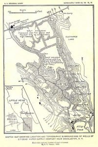
Looking south we see the Alley Creek/Oakland Lake outfall on the right. A little up from that the dredged portion of the creek ends and a winding natural portion ending at a small waterfall. The high grass lines are the drainage ditch lines that go back at least to the early 1900's. If you follow the one running south you see a different landscape. This was a fresh water marsh that emptied at the waterfall. Moon tides and storm tides rose above that level and salt mixed with fresh. The fresh comes from the water table following the contour of the land until the mud of the wetland where, unable to pass, it bubbles up in springs. The Citizens Water Supply pumped there until the 1920's when the City took over and switched to upstate sources. The white dots in the distant are cars on the Cross Island Parkway.


